Here we are again after more fantastic experiences including the personal
challenges in the Karijini National Park. We had a three night stay at
Dales Campground which was a great, natural, peaceful place to camp.
While there we managed to explore several gorges including the
Kalamina, Dales and the Weano and Hancock Gorges.
Karijini National Park

Firstly we checked out the Kalamina Gorge with its steep,
sheer rock face. Left of pic is the Kalamina Falls
which has only a very thin stream of water.

This cliff above looks like it's been manually layered this way
with interwoven slabs of rock.

The reflective and still water in the gorge.

Gerry's found a cliff to conquer.

And here (top left) he's made it high enough for a photo.

Just check out the blue, grey, purple and pink colours in the rock.

The next day while on the Dales Gorge clifftop walk, Gerry spotted
our travelling companions Marg & Richard down in the gorge below.
They had managed the steep descent into the gorge and you may be
able to see them (two little figures) camoflaged in the photo below....


On the gorge clifftop walk we came across our other travelling
companions Ray & Barb also enjoying their early morning stroll.

The view of the Circular Pool from the lookout above Dales Gorge.

The water trickling over the rocks makes a pretty sight.......

whilst the Circular Pool is a beautiful (but icy) swimming hole.

And further along the gorge, Gerry's foot (top right) almost got this
little ghecko... The ghecko spun around in defiance as if to say,
"Hey mate watch it!! This is MY ROCK!!!!"

Fortescue Falls in Dales Gorge was a perfect place for a refreshing dip in the
COOL water. We saw quite a few young daredevils climb onto the narrow rock
ledges on the left and dive in where fortunately it's deep enough.

The view from the top of Fortescue Falls with swimming hole below and the
rock ledges on right from where the young jump or dive into the pool.

The ledges on the rock face of Fortescue Falls is the only way down to the
pool, so we took extra care when heading down for a swim. You can get an
idea of how high the rocks are by the size of the people at top right and
bottom half of photo.

On the third day, along a gravel road on our way to the Weano and
Hancock Gorges, we came across this Blue-Tongue lizard.
The Blue-Tongue's main defence is bluff so when it feels threatened, it
opens its mouth and sticks out its blue tongue to frighten off the attacker.
It also hisses loudly and flattends its body which makes it look wider and
bigger. If you pick up the lizard now it will bite you and it will hurt.
Blue-Tongues have a habit of latching onto your finger and not letting go
which leaves you with a nasty bruise. We didn't get too close though, just
enough to take a photo while it just stayed put in the middle of the road.

Once in the Weano Gorge, we had to wade through water to continue on
the journey to the Handrail Pool so there was no option but to get wet.
On the left side it was deep enough to swim through but I chose to walk
and very carefully at that, as it was uneven and rocky under the water.

Here's one of the very clear pools in Weano Gorge. The only way
forward was to head along the narrow ledge of the pool or in the water.

This is the Handrail Pool in Weano Gorge. Check out the entrance point
through the deep narrow split in the rocks and if you look carefully you may see
the handrail to the right of the narrow entrance which you need to hang on to in
order to get into the pool area. That's me sitting on the ledge at the right side
of the pool. Once on the ledge it's difficult to keep your footing as the rock
ledges are very slippery. This part of the gorge is a Class 5 Walk
which I had never attempted before.
Class 5 Walk description is as follows:-
'Mostly indistinct trails through undisturbed natural
environments. Terrain is rough. A high level of fitness
is required. Users must be prepared and self reliant,
with advanced outdoor knowledge. Weather can
affect safety.'
Luckily I had Gerry to guide me otherwise I may not have
had the confidence to attempt any Class 5 Walk.

Here's a young lad helping his friend down the handrail.

On leaving Handrail Pool, hang on to the handrail and drag yourself up
as it's steep and slippery. But once up you can place your feet at the
rock edges which are mostly dry.

And there's still more climbing on the way out of the gorge. The water
here was too deep to wade through, so it was either swim or clamber
your way around the rock face. It was just a case of slowly does it and
I was really relieved that I was able to make it without falling in.

After a bit of lunch we tackled the next Gorge - the Hancock Gorge.
Here I am doing the Spider Walk into Kermit's Pool. Here it was either do
the Spider Walk or walk in the water which was quite shallow but fast flowing
and very slippery. The narrow section here is actually called the Spider Walk
and it's another Class 5 Walk! This time we just wore our bathers, shirt and
sandals as we'd been told there was a lot of water to contend with.
The hat is just part of our everyday gear with the hot sun ever present.

Here's Gerry in Kermit's Pool.

Now it's Gerry's turn to do the Spider Walk out of Kermit's Pool.......
Hey Jim & Caroline, just had to prove that OLD guys can do it too!!....
Hey Jim & Caroline, just had to prove that OLD guys can do it too!!....

and here he's tackling the ledges on the final leg out of the gorge.
Here the water again was too deep to wade through and with a good
camera onboard, swimming was out of the question. We thought
of you Jim & Caroline in this gorge after following your similar
adventures when you travelled this big country a few years back.
Here the water again was too deep to wade through and with a good
camera onboard, swimming was out of the question. We thought
of you Jim & Caroline in this gorge after following your similar
adventures when you travelled this big country a few years back.

Here we are enjoying happy avo back at Dales Campground which, as
you can see by the photo, is in a natural, native area, very spacious and
an ideal quiet place to relax in between exploring the area.
From Karijini we headed west and made a stop here....
Indee Station

The sign on the gate says Old Farts Haven... well it was very enjoyable
here especially with owners Colin & Betty who at 70yrs+ still cook the
meals for the workers and guests who wish to come along to join in the
dinner. If you're in the area it's worth a visit just to experience the
hospitality of the hosts, volunteers and workers and listen to their
stories. Don't forget to close the gate at the end of the 9km long,
red, dusty driveway when departing.
After a brief overnight stop here we headed on to....
Roebourne...
 This is the Historic Roebourne Goal where Aboriginal prisoners
used to be chained to the wall in one room housing eight prisoners.
It told a sad story of their past inhuman treatment.

 Cossack named in 1871 - in the Pilbara region at the mouth of the
Harding River, played a vital role as the port for Roebourne and the
surrounding area. The Pilbara gold rush in the late 1880's coincided
with the growth of the pearling industry to bring real prosperity to
Cossack. However by the turn of the century the pearling industry
had moved to Broome and the gold rush had dimished. Several
attempts were made to revive the town by introducing new
industries but by the 1950's the town was virtually abandoned.
Cossack has become a tourist attraction with the remaining
historic buildings.
 This building in Cossack was the Police Barracks and is now used
for Manager's quarters and budget accommodation.
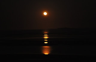 Cossack was also the place to view the 'Staircase to the Moon'
and it wasn't too bad a view considering the horizon was hazy
just when as the full moon came into view. You can just make
out the staircase-like ripple in the water at a very low tide.
Point Samson
 We also checked out nearby Point Samson with its beautiful
beach and colourful rock formations below.....

 We drove from Karatha to Dampier and saw this empty train
heading back to the mine for its next load of iron ore for shipping.
The reflection was provided by the water alongside the rail line.
 The beautiful Mulla Mulla at Fortescue River Rest Area CAW500
provides a picturesque stop for coffee along the highway heading
to our overnight stop at Barradale Rest Area CAW489.
Next we headed to Exmouth....
and did a day trip out to....
Turquoise Bay
 At Turquoise Bay (Ningaloo Marine Park) in the Cape Range National
Park we swam in the clear, cool water and Gerry tried his hand at snorkelling
at the reef. There were also plenty of fish swimming around us in the shallows.
The water was a briliant shade of turquoise.
That's Gerry sitting on the beach with his Akubra on the fence post.

This colourful display board at the Ningaloo Marine Park
at Turquoise Bay has the following warning for visitors to the reef:-
"Human activities have already destroyed and severely damaged many
of the world's coral reefs. The reef here at Turquoise Bay can be damaged
by snorkellers kicking the coral with their fins or standing on the reef."
We did a day trip from Exmouth to this beach and also
stopped at the Vlaming Head Lighthouse below....

 At Exmouth, a town with a population of about 2400, there is a large
new development of canal homes underway. The smallest block is about
200sq metres and prices start from $340,000! Exmouth was established
as a support town for the Harold E Holt Naval Communication Station,
a joint Australian and USA Government venture.
The town also has great bicycle paths.
Leaving Exmouth and heading south, Gerry and I took a 12km
detour off the highway to check out....
Coral Bay


Roebourne...

used to be chained to the wall in one room housing eight prisoners.
It told a sad story of their past inhuman treatment.

The weather bureau at the local fuel stop!
Cossack

Harding River, played a vital role as the port for Roebourne and the
surrounding area. The Pilbara gold rush in the late 1880's coincided
with the growth of the pearling industry to bring real prosperity to
Cossack. However by the turn of the century the pearling industry
had moved to Broome and the gold rush had dimished. Several
attempts were made to revive the town by introducing new
industries but by the 1950's the town was virtually abandoned.
Cossack has become a tourist attraction with the remaining
historic buildings.

for Manager's quarters and budget accommodation.

and it wasn't too bad a view considering the horizon was hazy
just when as the full moon came into view. You can just make
out the staircase-like ripple in the water at a very low tide.
Point Samson

beach and colourful rock formations below.....


heading back to the mine for its next load of iron ore for shipping.
The reflection was provided by the water alongside the rail line.

provides a picturesque stop for coffee along the highway heading
to our overnight stop at Barradale Rest Area CAW489.
Next we headed to Exmouth....
and did a day trip out to....
Turquoise Bay

Park we swam in the clear, cool water and Gerry tried his hand at snorkelling
at the reef. There were also plenty of fish swimming around us in the shallows.
The water was a briliant shade of turquoise.
That's Gerry sitting on the beach with his Akubra on the fence post.
This colourful display board at the Ningaloo Marine Park
at Turquoise Bay has the following warning for visitors to the reef:-
"Human activities have already destroyed and severely damaged many
of the world's coral reefs. The reef here at Turquoise Bay can be damaged
by snorkellers kicking the coral with their fins or standing on the reef."
We did a day trip from Exmouth to this beach and also
stopped at the Vlaming Head Lighthouse below....


new development of canal homes underway. The smallest block is about
200sq metres and prices start from $340,000! Exmouth was established
as a support town for the Harold E Holt Naval Communication Station,
a joint Australian and USA Government venture.
The town also has great bicycle paths.
Leaving Exmouth and heading south, Gerry and I took a 12km
detour off the highway to check out....
Coral Bay

Coral Bay situated just north of the Tropic of Capricorn, is the southern
gateway to the Ningaloo Marine Park. This is certainly a place we would
love to revisit on another trip. It's only a small place with limited shopping
and accommodation/caravan parks, but it is also quite peaceful.

Gerry's enjoying a stroll along the beach. We spotted
plenty of fish swimming in the shallow clear water.

Back on the main highway from Exmouth to Carnarvon we
passed this sign. The last time we saw a Tropic of Capricorn
sign was in Longreach QLD.
So that's it for another blog and our journey continues....
Till next blog keep safe and well!


