Well we made it to the Nullarbor on the last leg of our journey
around Oz. Apart from what we'd heard, we didn't really
have any set expectations except that it would be a long
road trip on the Eyre Highway and that we would
get to see some great coastal scenery.
So here's the last chapter of our blog......
around Oz. Apart from what we'd heard, we didn't really
have any set expectations except that it would be a long
road trip on the Eyre Highway and that we would
get to see some great coastal scenery.
So here's the last chapter of our blog......
The Nullarbor
(Treeless Plain)
The Nullarbor (nullus - no, and arbor - trees) is the section
of southern land between Norseman in Western Australia
and Ceduna in South Australia, a distance of 1209kms.
The Nullarbor Plain is a former shallow seabed located on the
Great Australian Bight with the Great Victoria Desert to its north.
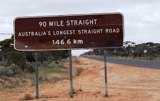
After leaving Norseman in WA we headed east on the Eyre Hwy
and saw this sign which relates to the stretch of road between
Caiguna and Balladonia.
The Eyre Highway across the Nullarbor is one of Australia's
greatest road journeys. It is named after the explorer Edward
John Eyre, who in 1841 barely survived thirst, hunger and
treachery by guides to make the first East-West crossing of
the continent.
Also on the Nullarbor is an RFDS emergeny airstrip on the
highway and for those not familiar with this, RFDS stands for
Royal Flying Doctor Service which is so vital to the outback.
This sign is in front of the Cocklebiddy Roadhouse.
Check out the population and animal stats and below the
almost deserted Cockle's Caravan Park.....
almost deserted Cockle's Caravan Park.....
...but each of our three free camps along the Nullarbor were
a little more inviting. Although the Nullarbor is mainly treeless,
some of the roadside camps did offer some protection from
the wind with trees and shrubs (CAW2 Najada Rockhole).
a little more inviting. Although the Nullarbor is mainly treeless,
some of the roadside camps did offer some protection from
the wind with trees and shrubs (CAW2 Najada Rockhole).
Here we are at Eucla in WA just west of the border between
Western Australia and South Australia....

....and here's the sign just east of Border Village which is
is the gateway to Western Australia and South Australia.
Along the Nullarbor in South Australia we got our first view of
the stunning Bunda Cliffs of
The Great Australian Bight -
(Bight means a bend in the coast that forms an open bay).
The Bunda cliffs pictured above, is an aboriginal name which has
been used in South Australia for the name of the Nullarbor coastal
cliffs. These limestone cliffs, which can be seen from Eucla to Madura,
are some 60 to 120 metres high and sheer, extending for around
100kms along the Great Australian Bight on the Southern Ocean.
In this photo (taken from the edge of Bunda Cliffs) you can just see
two road trains in the distance approaching each other on the
Eyre Hwy along the Nullarbor.
The Nullarbor Roadhouse is barely visible beyond
the sign looking east.......those dots on the horizon...
....and this view is looking west from where we've come.
There's some great signs along this road. Fortunately we
didn't encounter any of these animals on this stretch of road.
Further east we arrived at the viewing platform at the
'Head of Bight' on the Great Australian Bight with more of the
Bunda Cliffs behind us.
'Head of Bight' on the Great Australian Bight with more of the
Bunda Cliffs behind us.
This is the area to view the Southern Right Whales when they
come to this area from cold southern oceans to calve and breed.
The next landmass south of this point is Antarctica.
This bay at Head of Bight provides protection and warmer water
suitable for calving. The whales begin to arrive in May and by
September they are beginning to head south again. We were lucky
to still see several mothers with calves here in mid October.
Here are a few whales enjoying the calm waters of 'The Bight'
on the Southern Ocean.
on the Southern Ocean.
Seems like this young calf was really enjoying itself. It was lifting
its tail out of the water and slamming it down onto the surface
its tail out of the water and slamming it down onto the surface
with a resounding clap which is called a 'Tail Lob'.
There's one of the mother whales.
The adult whales have very wide tails.
So we left the Head of Bight with the last view of the
crumbling Bunda Limestone Cliffs......
and we continued our journey further east.....
to CAW797 Nundroo East where met up at a campfire with fellow
campers from a previous overnight rest area two days earlier.
campers from a previous overnight rest area two days earlier.
Meeting up with other campers after a day's driving and
sightseeing makes this long journey very interesting.
Two couples we met here have already crossed the Nullarbor 14
times and they have their favourite campspots. On the two nights
we met up, they provided firewood for us all to enjoy and it made
our camping experience on the Nullarbor quite special.
They are already aged in their 70s and they intend to keep
travelling this great country as long as they can.
we met up, they provided firewood for us all to enjoy and it made
our camping experience on the Nullarbor quite special.
They are already aged in their 70s and they intend to keep
travelling this great country as long as they can.
Early next morning a spider had been quite busy.
Next stop.......
Streaky Bay
Streaky Bay was first sighted in 1627 by Dutchman Peter Nuyts.
Nearly two centuries later in 1802 Captain Mathew Flinders
rediscovered and named Streaky Bay whilst examining the South
Australian coast in the ship 'The Investigator'.
He named Streaky Bay because of the streaks in the water
across the bay; (caused by the reflection of light and seaweed).
He named Streaky Bay because of the streaks in the water
across the bay; (caused by the reflection of light and seaweed).
Our van is just left of centre at the water's edge.
On this glorious calm afternoon we took the opportunity to enjoy
a ride on a bike path from the Streaky Bay Caravan Park.......
a ride on a bike path from the Streaky Bay Caravan Park.......

....and a short time later there's Gerry relaxing in his
chair with a drink on a calm, balmy evening.
chair with a drink on a calm, balmy evening.
Another unique sign on the wall of a souvenir store
in Streaky Bay.
From here we headed towards Port Augusta via the town of Kimba
where we just had a coffee stop and more photo opportunities.
where we just had a coffee stop and more photo opportunities.
This photo was provided by Marg our travelling companion who
by now was already in Victoria with Richard, Ray & Barb. Even
we were delayed because of work commitments, we still kept
in touch. So according to this sigh the town of Kimba is
'Half Way across Australia.'
in touch. So according to this sigh the town of Kimba is
'Half Way across Australia.'
Another great photo taken by Marg also in Kimba!
How's this for a toilet stop!
Kimba is known for its murals and this one as well as
the one below are on the wall of a large shed at the
Kimba Showrounds.
SHEEP wrecked! Love it!
Next stop.....
Mt Remarkable National Park
This park is located about 40kms south of Port Augusta.
We camped at the Mambray Creek campground CAW370,
a very peaceful bush setting with spacious camp sites.
a very peaceful bush setting with spacious camp sites.
Kangaroos crossed our path as we started our 11km hike.
We were again in awe of the stunning scenery on our hike
through the hills as shown above and below.
At first we'd planned one night here but as had happened previously
at other camps, we loved the area and had a day to spare so why not!
Our campsite is down in the valley...perhaps you can see a
few white dots in between the trees.
Some trees are amazing in their growth pattern.
We left Mt Remarkable and headed for Mannum via Burra.
Burra
Burra is a pastoral centre and historic tourist town in the
mid-north of South Australia. It is a former copper mining town
and in the photo below is one of three rows of 1, 2, and 3 room
cottages built in 1839-42 for William Paxton Director of South
Australian Mining Association.
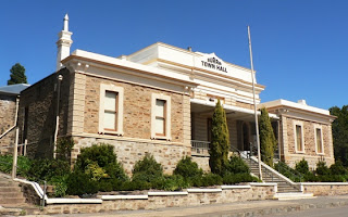
The Historic buildings also include the Burra Town Hall above
and below the General Store (now a Museum) and the Fire Station.
After a few hours at Burra we headed towards Mannum
but we just happened to drive past the....
Burra Creek Gorge....
.... and decided it would make a good lunch stop.
However it looked so inviting that we made it our overnight stop.
Another opportunity to take a hike up a hill and
balance on rocks in the creek crossing on the return trip.
Another great camping spot in serene surroundings and all that
at no cost! CAW298 in the Camps Australia Wide book.
Boy we love Australia!
From Burra Creek Gorge on to...
Mannum
Originally established in 1839, the Wellington Punt was the
earliest and most important ferry crossing on the Murray River.
It was a vital link on the Great Eastern Road to Victoria, being
used by travellers, stock and the mail service.
Here's our camp CAW237 Bolto Reserve on the
banks of the Murray River.
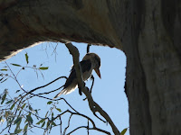
At our camp we had a visit from a Kookaburra and a Heron.
The PS Marion floated in 1897, is one of the first original wood-fired
paddle steamers to run cruises on the Murray River and is now
available for river cruises and tourist accommodation.
The next day we drove into Murray Bridge over the bridge below.
When the Murray Bridge Bridge was opened in 1879,
it was the first bridge to span the Murray River.
It's a very narrow bridge with fortunately a low speed limit
and we just made it past this truck with our caravan in tow.
and we just made it past this truck with our caravan in tow.
Thanks again to Marg for this photo of the mural at Bordertown,
that's the border between South Australia and Victoria.
A few hours into Victoria we had planned to stay overnight at
another roadside rest area enroute to the Grampians National
Park. However we'd heard that our (favourite) nephew Jim was
leaving Halls Gap in the morning. So what to do??
As Jim was hoping to catch up with us before heading home,
we decided to keep driving, so after 540kms and much to his
and my sister's delight we arrived a day early at.....
Halls Gap
in the Grampians National Park
ridges running north to south with steep and craggy slopes
on the eastern side and gentler slopes to the west. They are
the result of earth movements lifting and tilting the hard
sandstones creating an impressive landscape of peaks and
valleys. There are lookouts with stunning panoramic views
as well as a number of picturesque waterfalls.
that's the border between South Australia and Victoria.
A few hours into Victoria we had planned to stay overnight at
another roadside rest area enroute to the Grampians National
Park. However we'd heard that our (favourite) nephew Jim was
leaving Halls Gap in the morning. So what to do??
As Jim was hoping to catch up with us before heading home,
we decided to keep driving, so after 540kms and much to his
and my sister's delight we arrived a day early at.....
Halls Gap
in the Grampians National Park
It didn't take us long to get settled at the Halls Gap
Caravan Park in the Grampians National Park.
The Grampians are a series of five spectacular sandstone ridges running north to south with steep and craggy slopes
on the eastern side and gentler slopes to the west. They are
the result of earth movements lifting and tilting the hard
sandstones creating an impressive landscape of peaks and
valleys. There are lookouts with stunning panoramic views
as well as a number of picturesque waterfalls.
The early morning mist hung over the mountains in Halls Gap....
....but it wasn't long till the mist cleared and the kangaroos could
enjoy lazing in the sun in the caravan park.
When daughter Michelle and son-in-law Ash arrived at camp
along with our grand-daughter Jessica they took Gerry for some
serious 4 wheel driving but needed some assistance when they
got stuck! Soon after they left I got the phone call for help but
when I arrived another 4x4 enthusiast was happy to assist with
his winch. This area had experienced flooding recently and left
the conditions perfect for their type of fun.
There's Ash wading thro' the mud to connect the winch!
He said he had the best time ever and the others agreed. As
far as he's concerned the more mud on the car the better!
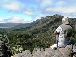
Another day and Gerry and I enjoyed our hike up
Chitaqua Peak.
The view over the Halls Gap township and Lake Bellfield
was well worth the effort!
Cycling at Halls Gap is also great with brilliant scenery.
I don't think this bull was too happy about us stopping at the
fence as he got up, stamped his feet, came over and.......
......told us to f*#&$%#*#^ BUGGER OFF!
Don't believe me? You read his lips then!
A typical old deserted 'Aussie' shack in the Grampians.
This 'Bunjil Cave' near Stawell has some great aboriginal
rock art, difficult to get a photo due to the security fence.
Our final camping spot was at the Grampians Gate Caravan Park
in Stawell and here's Gerry relaxing by the lake with Richard.
This is where we met up with our friends from the
Geelong Caravan Club on the Melbourne Cup Rally.
Happy afternoon by the lake with the group was very enjoyable
and a great way for us to finish off our trip around Oz.
But before we left Stawell, Gerry was thrilled to find this
brilliant Bee Orchid! Wow this was great as we'd seen so
many beautiful orchids in Western Australia and we hadn't
expected to see such a beautiful one here near Stawell.
Well after 22,900 kms this journey has finally come to an end
and we're now enjoying being at home in Ocean Grove. It was
so good to see all our family again as we did miss them but we
wouldn't hesitate to do it all again. On the map above you will
see the red arrows indicating the anti-clockwise direction we
travelled and the dark green marks are the places we camped.
We've been asked 'what was the best thing about the trip....'
- that's really difficult to say as there were so many highlights
and too many wonderful places to name a particular one.
But in saying that.....Western Australia is big...and brilliant!!
When asked 'were there any things which disappointed us.....'
- we would have to say the amount of litter at roadsides, on walking
tracks and sometimes even the odd stubbie or two at waterfalls.
It's such a shame that some people can't enjoy nature and leave
it clean the way they found it, so that we can all enjoy it and see
nature the way it's meant to be.
Australia is a magnificent country with stunning scenery,
wide open spaces, old country towns with much history,
great outback hospitality, colourful characters, and many
wonderful fellow travellers you meet along the way.
We consider ourselves blessed to have been able to do
this trip and thankful that we've enjoyed good health.
A big thankyou to our travelling companions for the larger part
of our trip - Ray & Barb for all the work they put it particularly
Ray with the itinerary and Richard and Marg for all your
humour, support and enthusiasm.
We hope you've enjoyed following our journey on this blog
and we've certainly enjoyed the blogging experience.
Love to all.....till next trip then......but when????
Maria & Gerry


